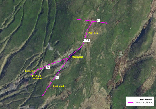

In October 2015 the EMRG commissioned an electrical resistivity tomogrophy (ERT)
Survey of the Comet Lode opencast at Copa Hill from the geophysical company
TigerGeo Ltd.
This was undertaken to help determine the depth and shape of the floor of this
Buried opencast as well as the land surface beneath the prehistoric spoil heaps
various conclusions could be drawn from the results of the profiles shown here,
although any final conclusions are still open to interpretation.
Cwmystwyth Geophysical Survey 2015 -2016
Location of ERT profiles, Comet Lode Opencast and tips (TigerGeo Ltd.)
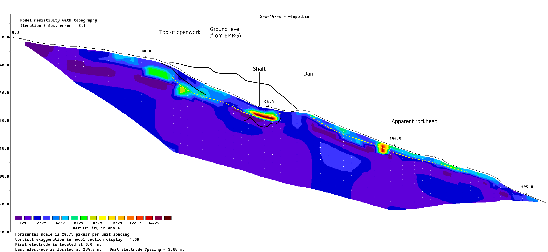
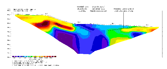
Profiles 1 and 2 implied the existence of up to 5m of resistive ground down slope of the
opencast above what must be bedrock. This consisted of up to 2m of tip overlying
what is probably colluvium or moraine.
The openwork itself appears to be about 7m deep below the top of the fill close
to the entrance and perhaps 14m below the original ground level at its deepest point.
At the northern end of the openwork the rock face appears to rise vertically from the
base of the working at about 60m along the profile, and from a depth of about 5-6m
below the surface of the opencast infill.
Profile 3 (approx. 70m E-W) was examined some 60m to the north of the open cut.
This appears to suggest another 4m deep peat filled gully or mine working lying along
The projected line of the vein. This had not been suspected.
opencast above what must be bedrock. This consisted of up to 2m of tip overlying
what is probably colluvium or moraine.
The openwork itself appears to be about 7m deep below the top of the fill close
to the entrance and perhaps 14m below the original ground level at its deepest point.
At the northern end of the openwork the rock face appears to rise vertically from the
base of the working at about 60m along the profile, and from a depth of about 5-
Profile 3 (approx. 70m E-
The projected line of the vein. This had not been suspected.
![]()
![]()
![]()
![]()
![]()
![]()
This website was made possible by a grant from the Cambrian Archaeology Association
Profile 2 - Comet Lode Opencast and Tips
Profile 3 - North of Opencast
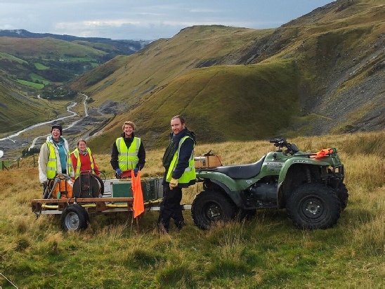
TigerGeo Survey team on Copa Hill, October 2015 (TigerGeo Ltd.)